
Tiernaur Loop Walk
A satisfying 13 km circuit tracing quietly flowing salmon rivers, ancient stone bridges, and serene bogland tracks beneath the dramatic shadows of the Nephin Beg Mountain Range.
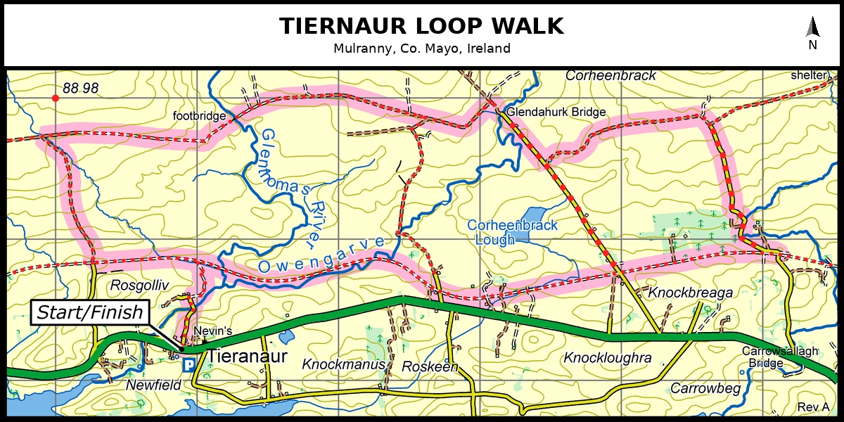
River Valleys, Mountain Backdrop & Quiet Country Roads
Located just 3 km east of Mulranny along the scenic N59 coast road, the Tiernaur Loop is the longest of the popular Burrishoole Loop Walks. Marked by Red arrow on white background waymarking arrows, this 13 km circuit delivers a wonderful mixture of quiet paved boreens, active farmland, and wild river pathways.
The trail begins near Tiernaur Church and Nevin's Newfield Inn, heading north toward the foothills of the rugged Nephin Beg Mountain Range. Crossing rural townlands like Rosgolliv and Srahacorick, hikers follow quiet lanes carved alongside the pristine Owengarve River.
Crossing historic stone footbridges such as Glendahurk Bridge, the route weaves past peaceful mountain loughs including Corheenbrack Lough before looping back south through Knockbreaga and Knockloughra.
With its moderate grade and modest 100m climb, the Tiernaur Loop offers half-day walkers an authentic taste of County Mayo’s inland valleys away from coastal crowds.
Trail Waypoints: Tiernaur Loop Walk
1. Tiernaur Church & Rosgolliv Lane
Start at the parking area near Tiernaur Church or Nevin's Newfield Inn off the N59. Follow the blue waymark arrows along the quiet parish road heading north into Rosgolliv, skirting small pastures and farmsteads.
2. Owengarve River & Srahacorick
The path meets the fast-flowing Owengarve River. Cross over the wooden footbridges near Glenthomas and turn northeast along Srahacorick, taking in open views of the heather-clad Nephin Beg peaks ahead.
3. Glendahurk Bridge & Corheenbrack Lough
Follow the track eastward across historic Glendahurk Bridge. Skirt the shores of Corheenbrack Lough while taking advantage of sheltered mountain valleys before the trail turns southward toward Knockbreaga.
4. Knockloughra & Return to Start
Descend through Knockloughra and Carrowbeg along tree-lined lanes. The trail leads back parallel to the N59 main road, completing the 13 km loop directly at your starting point in Tiernaur.
Hiker Tips & Safety Guidance
Due to the 13 km distance, bring adequate drinking water, snacks, and waterproof outerwear. Parts of the track run over quiet public roads—always walk on the right facing oncoming traffic.